Turncarver
A Photo Journal
V2_2505151625
July 2022: The Loowit Trail
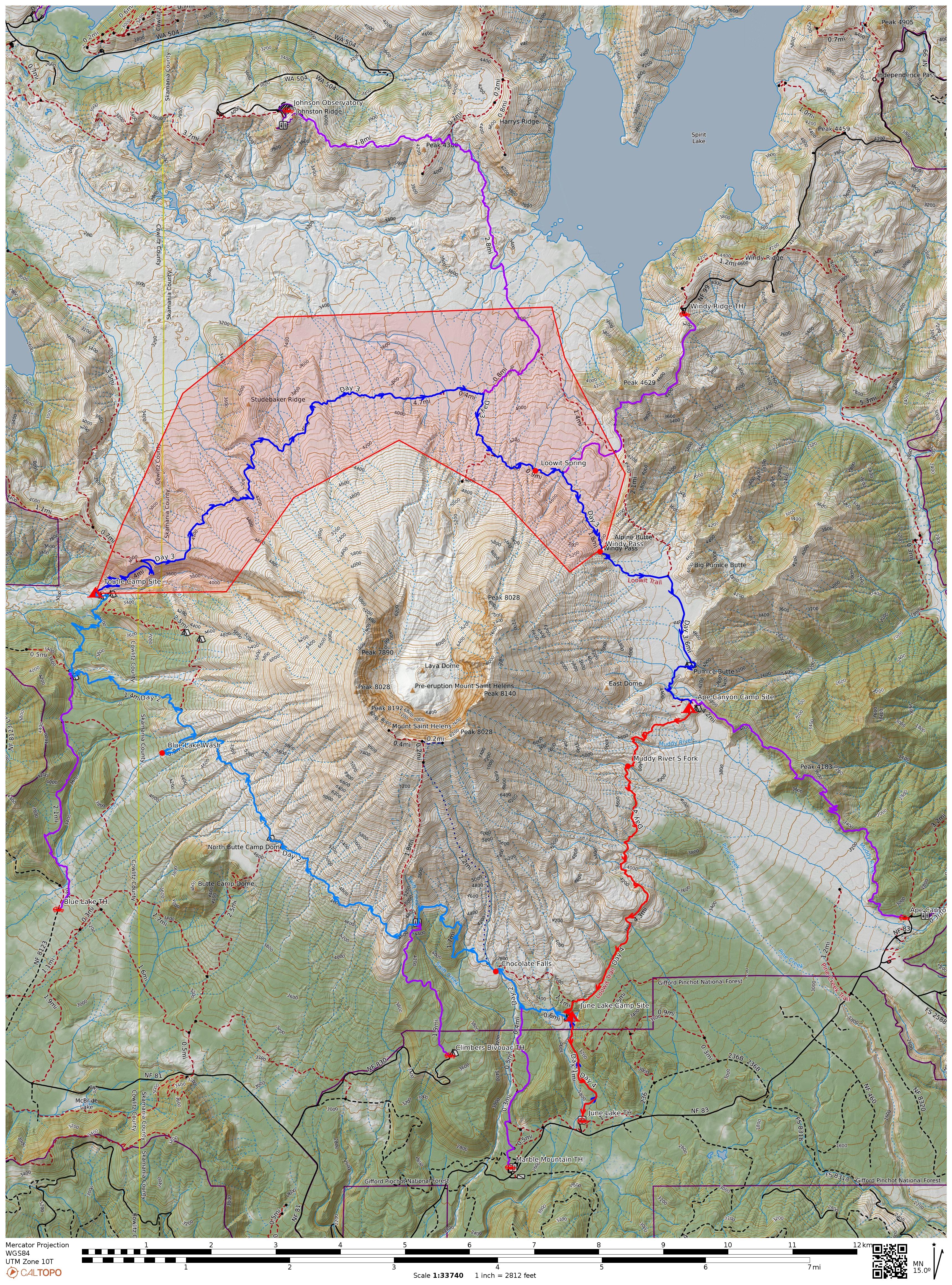
- Day 1: Light blue line
- Day 2: Dark blue line
- Day 3: Red line
- Alternate trailheads: Purple lines
- (First night hike to June Lake is not shown)
We hiked the Loowit Trail in a clockwise direction starting at June Lake. This
broke the trip down into long days on Saturday and Sunday, with an easy walk out on
Monday morning. On Friday evening we hiked in to June lake to camp. On Saturday
we hiked the South Toutle river at the edge of the blast closure area; we took a
detour to Sheep Canyon. We hiked through the blast closure (9.3 miles) then on to
the Ape Canyon trail to camp. On Monday we hiked back out via June Lake. The map
(at left) shows the route in detail.
Trip Data
| Trip Date: | July 15, 2022 – July 18, 2022 |
| Weather: |
Mostly Sunny on July 15 & 16 with temps in the low 70s
High clouds obscured the upper mountain on Sunday July 17 with temps in the high 60s. The clouds lifted throughout the day, but the top of mountain was not visible Foggy in the morning Monday July 18 with clearing in the afternoon. Temperatures in the 60s during our hike (before noon). |
| First Night | Day 1 | Day 2 | Day 3 | |
|---|---|---|---|---|
| Total Distance | 1.4 mi | 12.0 mi | 12.4 mi | 6.2 mi |
| Max Elevation | 3,144 ft | 4,778 ft | 4,846 ft | 4,468 ft |
| Elevation Range | 2,730 ft to 3,144 ft | 3,175 ft to 4,778 ft | 4,193 ft to 4,846 ft | 2,730 ft to 4,468 ft |
| Total Ascent | 422 ft | 2,925 ft | 2,741 ft | 601 ft |
| Total Descent | 0 ft | -2,893 ft | -1,693 ft | -2,084 ft |
| Travel Time (incl Stops) | 0:38 | 9:18 | 9:01 | 3:36 |
| Max Elevation: | 4,846 ft |
|---|---|
| Elevation Range: | 2,730 ft to 4,846 ft |
| Total Total Ascent: | 6,670 ft |
| Total Descent: | -6,670 ft | Total Miles: | 28.1 mi | Travel Time: | 22:33 |
Observations
- We travelled on a weekend and saw plenty of people - it would be less crowded on weekdays
- We travelled clockwise from June Lake - that was a good option because it split the days up well and made the last day very easy.
- A good option for a counter-clockwise walk would start/end at Windy Ridge
- South Toutle River is a popular campsite because people are getting ready to enter or have just exited the blast zone. Camping there is limited - arrive early.
- If travelling counter-clockwise, it may be better to load up on water at the S. Toutle River then climb an additional 1.6 miles / 1,500 ft on the Loowit trail to some campsites around 4,500 ft. We did not visit these sites because we detoured through Sheep Canyon, but other trail users said they are nice (but dry)
- Another counter-clockwise option is to continue 1.6 miles along the Toutle Trail to the Sheep Canyon trail (mostly level). There are a few sheltered campsites with good water.
- We detoured to the Sheep Canyon / Toutle Trail intersection to investigate camping options. It's a good place to camp, but camping there will add another 1.6 miles onto the hike through the blast zone (if traveling clockwise).
- The no-camping area around the blast zone is 9.3 miles with a net gain of 1,000 feet (travelling clockwise)
- The scenery is spectacular
- It can be windy, particularly at Windy Pass
- There was a little water at the bottom of the east side of Windy Pass (entering Plains of Abraham), but it does not appear to be a reliable water source
- The Plains of Abraham are flat, and its not hard to find a place to pitch a tent. When we were there it was windy, and there is no shelter. We did not find it suitable for camping
- There was a small trickle of water at Pumice Butte. There were also several nice camping sites, but it too was windy. (Wind is probably a common occurrence - one of the campsites had an improvised rock wind barrier.)
- We were able to find nice sheltered (from the wind) camping at the intersection with Ape Canyon trail. This camping area was dry.
- By the time we reached Ape Canyon trail we'd travelled over 12 miles. Had we camped at Sheep Canyon the night before, this would have been a long day.
- There was still a lot of snow on the upper mountain, but water sources were still less than plentiful. Another traveler told us water was much more abundant than the last time she walked the trail. We found water at
- June Lake (plentiful, year-round source)
- Chocolate Falls (barely enough flow to dip a water bottle - probably not year-round)
- Junction of Sheep Canyon and Toutle trails (plentiful, year-round source)
- South Toutle River (plentiful, year-round source)
- A few streams in the blast zone (probably not year-round sources)
- Loowit Creek - below Loowit Falls (plentiful, year-round source)
- A spring (oasis?) between the Loowit Falls trail and the Windy Trail (plentiful, year-round source)
- A stream on east side of Windy Pass, entering the Plains of Abraham (probably not year-round)
- A small stream at Pumice Butte (probably not year-round)
- South fork of the Muddy River (plentiful, probably a year-round source)
- We did not encounter any mosquitos or biting insects
- We encountered two places where we had to wade across deep water:
- South Fork of the Toutle River (we made it across without wading, but most people waded)
- Toutle Creek