Turncarver
A Photo Journal
V2_2609031654
October 2008: Through-hike in the Enchantments
“The Enchantments” refers to an alpine valley in the Washington Cascades
near the town of Leavenworth. The high valley contains spectacular lakes
and granite formations, and is well-known for its larches, which produce
brilliant fall colors. Due to the popularity of this area, camping and
hiking are regulated. Permits are required for overnight camping, and
are generally reserved well in advance for summer weekends. Day hiking
is not restricted, but a $5 trail permit is required (and can be
purchased at the trailhead).
Two trails provide accessto the Enchantments: trail 1553 from the
Snow Lakes trailhead or trails 1599 & 1599.1 via Colchuck Lake from
the Stuart Lake trailhead. One-way distance from one trailhead to
the other is 18 miles. Because this is such a long hike, most parties
camp overnight or hike only a portion of the trail. A through-hike
can require up to 14 hours depending on the strength of the party and
the amount of time spend enjoying the sites. The trailheads are
about 8 miles apart by road, so a through-hike requires 2 cars to
shuttle between trailheads or some other plan to return to the starting point.
More information about the Enchantments can be found at
the WTA Website.
A WTA article on larches can be found here.
-------------------------------------
It was a clear, sunny day and the fall colors, while not at their peak,
were spectacular. We elected to ascend via Aasgard pass and return
along the Snow Lakes trail. This would put the climb behind us quickly,
and we would be in the valley before lunch. We left the Colchuck
parking lot (3,475 feet) at 7:00AM; it was barely light enough to
alk without headlamps. It was also cold (about 25 degrees). Because
the Colchuck trail is north of Aasgard pass and Dragontail Peak, it
remained in shadow for our entire ascent (and most of the day). We
could see the sun on the peaks above us, but did not emerge into sunlight
until we reached the top of the pass.
The trail to Colchuck lake starts as a gentle grade which steepens
after crossing the stream about 2.3 miles into the hike. After 4
miles we reached Colchuck lake. The increase in elevation (2,200 feet)
and lack of sunlight made it cold enough that we had to keep moving to stay warm.
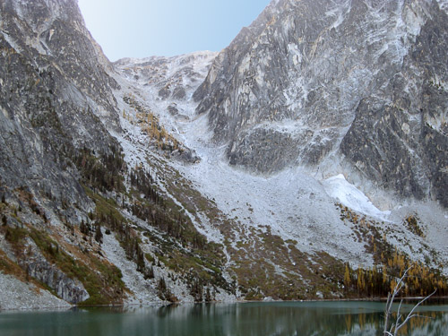
Aasgard Pass rises steeply from the southern end of
Cochuck Lake, following a corridor between rock faces to the
east and west. The trail ends about two thirds of the way around
the lake. We continued traveling, following cairns and a climber's
track over boulder fields and through the brush until we reached
the base of Aasgard Pass. About half way up, the slope is broken
by a rocky outcropping housing a few larches. A stream flows down
the west side of the corridor; the climber's track passes to the
east (left) of the outcropping
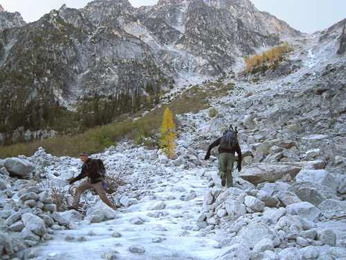
We began our climb on the rocky slope beside the stream on the
west (climber's right) side of the corridor. The stream, which
begins as a series of cascading falls near the top of Aasgard
Pass, was frozen solid; crossing was tricky. After crossing
the stream, we worked our way to climber's left to pass between
the rock outcropping and the east wall. After passing the
outcropping we worked our way toward the center of the corridor
and began the scramble up the final slope to the top. The top
of Aasgard Pass is an easy class 2+ scramble (requires some use
of upper body), but on this climb it was tricky because many of
the rocks were covered with frozen water. At about 11:30 we
reached the top (6.1 miles; 7,814 feet) and broke out into the sun;
it was immediately warmer (40's or 50's).
After warming up at the top of Aasgard Pass we spent about 2 hours
working our way down through the lakes, larches, and slick rock that
comprise the high valley of the enchantments. There was a fresh
dusting of snow, and the smaller lakes at the top had a thin layer
of ice on top. As we hiked lower we moved into the larches, which
were bright yellow, just beginning to turn orange. We ate a late
lunch at the low point below / east of perfection lake (8 miles,
7,063 feet), leaving around 2:00PM to begin our descent.
The descent to Snow Lakes begins at Lake Viviane (8.8 miles, 6,700
feet). We had one minor detour as we followed a side trail to toilet
hidden in the rocks overlooking Snow Lakes. After regaining the trail,
we descended steeply for about 1.2 miles to upper Snow Lake (10 miles,
5,475 feet). The trail improved at this point, and we picked up our
pace for the long walk to the parking lot (18 miles, 1,336 feet). The
Snow Lakes trail is long, and a bit of a slog, but it was very pretty
in the fall colors.
A few things we learned
- The Colchuck trailhead is significantly higher (2,100 feet) and colder than the Snow Lakes trailhead. The temperature was about 25 degrees at the Colchuck trailhead when we left in the morining; when we arrived at the Snow Lakes trailhead at 7:00 PM we were in shirtsleeves. Upon returning to the Colchuck trailhead to pick up our car we needed heavy coats.
- We would have needed headlamps if we'd started 15 min earlier or ended 15 min later (we had almost exactly 12 hours of usable daylight).
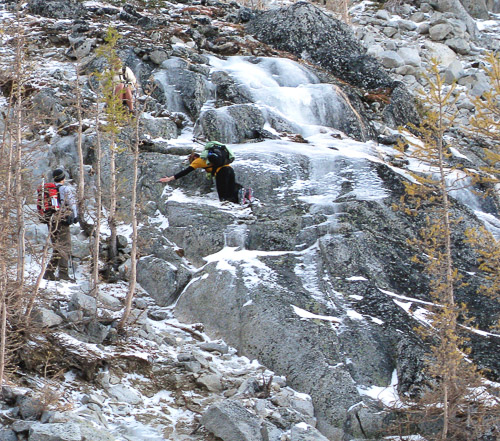
- The ice on Aasgard pass can be dangerous. When we crossed the stream at the bottom it was tricky (as in break a leg or arm); when we encountered it again near the top, where you need to scramble up rocks using your hands, it was downright dangerous. I was glad we did not attempt to descend it (although several parties did the day we hiked).
- Ultimately, its "bark is worse than its bite" - I didn't have any real difficulty or lingering aches afterward. The only problem I had was blisters on my toes (we all had blisters). If I did it again, I'd eat a late lunch at the same place and take the extra time wrap all blister-prone spots before continuing. I'd also stop and "wrap" again at snow lakes (a steep 2 miles later) - there's a nice area right after you cross the dam between the lakes; the blister “hot spots” will be apparent by then, and there's still have 7 or 8 miles to go. If you stop to take care of the blisters early, you'll make up the time by walking faster over the next 8 miles.